Jervis Bay
Jervis Bay is a 102-square-kilometer oceanic bay and village on the south coast of New South Wales, Australia, said to possess the whitest sand in the world. It is surrounded by Jervis Bay and Wreck Bay.
A 70-square-kilometer area of land around the southern headland of the bay is a territory of the Commonwealth of Australia known as the Jervis Bay Territory.
Several features at Jervis Bay have been used as evidence that the Australian coast experienced many giant tsunamis prior to European colonization.
Tourism & What to do in Jarvis Bay
Tourism in Jervis Bay is one of the most important avenues of income for many of the local residents, with many businesses orienting themselves towards it.
Jervis Bay is well known for recreational fishing, kayaking, paddleboarding, sailing, and scuba diving, with tour operators departing from Huskisson and amateurs using boat ramps at bayside towns and campsites.
Popular diving sites include The Labyrinths, Gorgonian Wall, Point Perpendicular, a submerged Fairey Firefly airplane, scallop beds, Middle Ground, Ten Fathom Reef, and Bowen Island.
Jervis Bay is also known for whale watching, because whale migration, both north, and south, can be observed as the animals pass the entrance to the bay, frequently entering the sheltered waters to rest.
The majority of whales sighted at Jervis Bay are humpbacks, which migrate along Australia’s east coast from June to November. Southern right whales are also showing a slow but steady increase in recent years as they re-colonize former habitats, having been extensively hunted in the 19th and 20th centuries.
Other species sighted have been false killer whales, orcas, minke whales and, on one occasion, a blue whale.
Significant areas of the Jervis Bay natural environment are Booderee National Park, Jervis Bay National Park and the Jervis Bay Marine Park.
Some 158 square kilometers of the land on both sides of the bay have been identified by BirdLife International as an Important Bird Area (IBA) because the coastal heathland supports the largest sub-population of the endangered eastern bristlebird, isolated from other sub-populations.
The place is a popular holiday destination since there are numerous pristine white sandy beaches and crystal clear water. Jervis Bay has been recorded as having the whitest sand in the world.
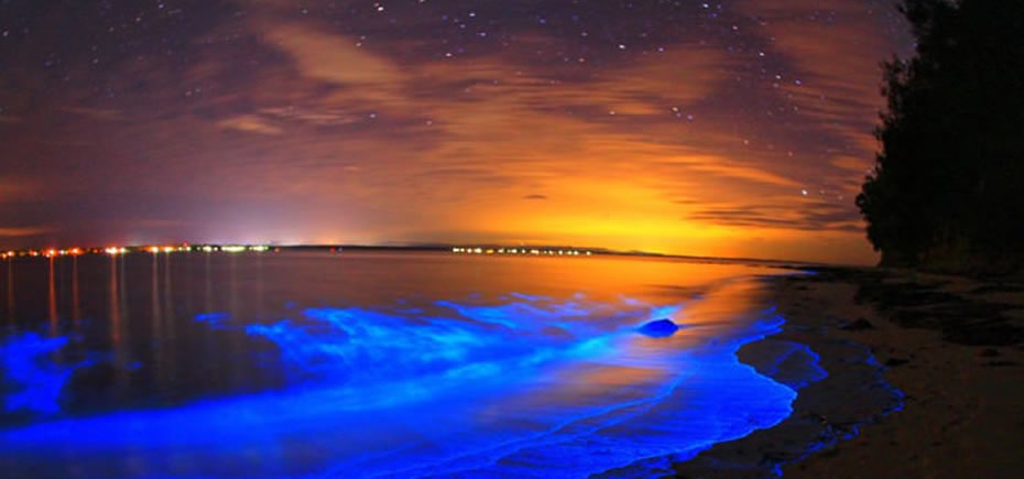
The bright blue bioluminescent algae glow
Due to the chemical reactions, plankton becomes luminescent. Therefore, the marine creatures emanate this dazzling blue glow. The sites like the Hyams Beach are indeed very romantic at night.
It is said that it is hard to spot these glowing delight because they are erratic and just the right conditions must be fulfilled for us to enjoy this! Based on my research, these are the conditions:
- It must be night/dark
- There would be red algae bloom in the water during the day (aka red tide)
- Naturally for red algae to bloom, the water must be rich in nutrient and warm
- Warm temperatures = warm waters (i.e. likely spring-summer months)
- Especially during the surge/transition between winter & spring (Sept) and spring & summer (Jan) when the waters suddenly become significantly warmer
- High acidity in the water
- Onshore wind & the right tides
The Jervis Bay Visitors Information Centre is at Huskisson and is part of the Lady Denman Maritime Museum and Gallery.
Local Council-managed Visitor Information Centres are at Nowra and Ulladulla.
Climate & Best time to visit
Jervis Bay experiences an oceanic climate, with average maximum temperatures varying from 16°C in winter to 25°C in summer tempered by sea breezes. The highest recorded temperature is 42.1°C in January, and the lowest 4.7°C in August.
Hot summer evenings are sometimes relieved by a front of rapidly moving cool air known as a southerly buster.
Rainfall is fairly evenly distributed throughout the seasons, with a bias to the first half of the year, due to prevailing easterlies. Short high intensity rainfall events may happen at any time of the year and can lead to local flooding. Jervis Bay also experiences thunderstorms during the warmer months bringing lightning, heavy rain and occasionally hail.
Yearly rainfall is influenced by the El Niño-Southern Oscillation.
Geography
In the Jervis Bay Territory on the southern side of the bay are the settlements of Greenpatch, Hyams Beach, and Bowen Island.
From north to south on the New South Wales shore of the bay are Callala Beach, Callala Bay, Huskisson and Vincentia.
The Australian Navy base, HMAS Creswell, is in the Jervis Bay Territory between Jervis Bay Village and Greenpatch Point. Beecroft Peninsula, on the northern side of the bay, has been used as a bombing range by the Australian Navy.
Origin of the name
Jervis Bay is named after Sir John Jervis, Admiral of the Fleet, Earl of St. Vincent, and first Viscount St. Vincent.
History & Timeline
Jervis Bay is a drowned river valley and formed 15,000 years ago, at the end of the last ice age. The bay took on its present appearance around 4000 BC after the sea levels had risen 120 metres, and as sand dune barriers created the southern peninsula.
Much of the rock in Jervis Bay is part of the Sydney Basin sandstone formation, which is 280-225 million years old, although lower areas are overlain with Tertiary-era sediments.
Archaeological evidence at Burrill Lake, 30 kilometres south of Jervis Bay, shows Aboriginal occupation dating back 20,000 years.
Jervis Bay was sighted by Lieutenant James Cook aboard HMS Endeavour on 25 April 1770 (two days after Saint George’s Day) and he named the southern headland Cape St George.
In August 1791 Lieutenant Richard Bowen, aboard the convict transport ship Atlantic, part of the Third Fleet, sailed into the bay and named it in honour of Admiral John Jervis, under whom he had served.
In November 1791 Master Matthew Weatherhead entered the bay aboard Matilda, which had also been part of the Third Fleet, in order to undertake repairs to the ship.
In mid 1797, survivors of the wreck of Sydney Cove passed through the area on foot, while undertaking an arduous trek of 600 kilometres in an attempt to get to Port Jackson (Sydney) – only three of them completed the journey.
Explorer George Bass entered the bay on 10 December 1797 and named Bowen Island.
Alexander Berry’s takeover of land in the Shoalhaven displaced Aboriginal people who were moved in 1822 to Wreck Bay. Smallpox and syphilis significantly reduced local populations.
A separate population of Aborigines, who settlers called ‘the Jervis Bay tribe’ – the Wandandian people – remained on their traditional lands on the bank of Currambene Creek (near Huskisson) and around St Georges Basin, until well into the C20th.
In 1841, the township of South Huskisson on Jervis Bay was founded as a seaport and terminus of The Wool Road.
The land now comprising the Jervis Bay Territory was surrendered by the state of New South Wales to the Commonwealth Government in 1915 to provide a seaport for the new Federal capital under construction at Canberra, which would be Australia’s only inland capital.
In the late 1960s, Australia’s first nuclear power plant was proposed for the area, and a site was prepared. However, the project did not proceed.
How to get there & Transportation
Point Perpendicular forms the southern end of the peninsula. Jervis Bay is approximately a three-hour drive south of Sydney. A door to door shuttle service is available between Sydney Airport and the South Coast every day.