Toronto
Toronto is the provincial capital of Ontario and the most populous city in Canada, with an estimated population of almost 3 million (2018) and an estimated population of more than 6 million in the Toronto Region (2018).
Toronto is an international center of business, finance, arts, and culture. Its large population of immigrants from around the globe has also made Toronto one of the most multicultural and cosmopolitan cities in the world.
Located on the shores of the western end of Lake Ontario, Toronto is also the anchor of the Golden Horseshoe, an urban agglomeration of 9 million (2016) that accounts for a significant portion of
Toronto is generally considered the financial capital of Canada. The city is also an important center for the media, publishing, telecommunication, information technology, and film production industries.
Tourism & What to do in Toronto
Toronto’s buildings vary in design and age with many structures dating back to the early 19th century, while other prominent buildings were just newly built in the first decade of the 21st century. Bay-and-gable houses, mainly found in Old Toronto, are a distinct architectural feature of the city. Defining the Toronto skyline is the CN Tower, a telecommunications and tourism hub. Completed in 1976 at a height of 553.33 meters, it was the world’s tallest freestanding structure until 2007 when it was surpassed by Burj Khalifa in Dubai.
Toronto is a city of high-rises, having 1,800 buildings over 30 meters.
Through the 1960s and 1970s, significant pieces of Toronto’s architectural heritage were demolished to make way for redevelopment or parking.
In contrast, since 2000, Toronto has experienced a period of a condo construction boom and architectural revival, with several buildings by world-renowned architects having opened.
Neighborhoods
The many residential communities of Toronto express a character distinct from the skyscrapers in the commercial core. Victorian and Edwardian-era residential buildings can be found in enclaves such as Rosedale, Cabbagetown, The Annex, and Yorkville. The Wychwood Park neighborhood, historically significant for the architecture of its homes, and for being one of Toronto’s earliest planned communities, was designated as an Ontario Heritage Conservation district in 1985.
The Casa Loma neighborhood is named after “Casa Loma”, a castle built in 1911 by Sir Henry Pellat, complete with gardens, turrets, stables, an elevator, secret passages, and a bowling alley.
Spadina House is a 19th-century manor that is now a museum.
Old Toronto
The pre-amalgamation City of Toronto covers the downtown core and also older neighborhoods to the east, west, and north of it. It is the most densely populated part of the city.
Old Toronto is also home to many historically wealthy residential enclaves, most stretching away from downtown to the north.
East and west of downtown, neighborhoods are home to bustling commercial and cultural areas as well as communities of artists with studio lofts, with many middle- and upper-class professionals.
Other neighborhoods in the central city retain an ethnic identity, including two smaller Chinatowns, the Greektown area, Little Italy, Portugal Village, and Little India, along with others.
Industrial
In the 1800s, a thriving industrial area developed around Toronto Harbour and lower Don River mouth, linked by rail and water to Canada and the United States. This industrial area expanded west along the harbor and rail lines and was supplemented by the infilling of the marshlands on the east side of the harbor to create the Port Lands.
A garment industry developed along lower Spadina Avenue, the “Fashion District”. Beginning in the late 19th century, industrial areas were set up on the outskirts, such as West Toronto/The Junction, where the Stockyards relocated in 1903.
The Great Fire of 1904 destroyed a large amount of industry in downtown. Some of the companies moved west along King Street, some as far west as Dufferin Street; where the large Massey-Harris farm equipment manufacturing complex was located.
Over time, pockets of industrial land mostly followed rail lines and later highway corridors as the city grew outwards. This trend continues to this day.
Public places
Toronto has a diverse array of public spaces, from city squares to public parks overlooking ravines.
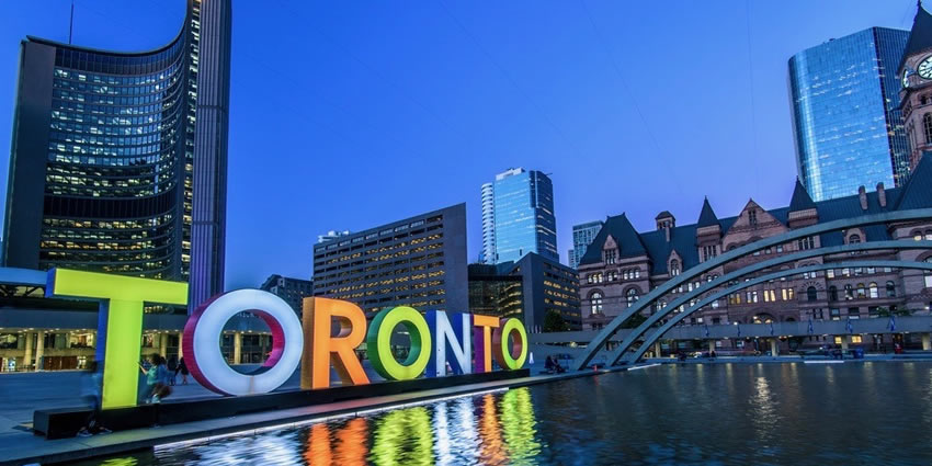
Nathan Phillips Square is the city’s main square in downtown, contains the 3D Toronto sign, and forms the entrance to City Hall.
Yonge-Dundas Square, near City Hall, has also gained attention in recent years as one of the busiest gathering spots in the city.
Other squares include Harbourfront Square, on the Toronto waterfront, and the civic squares at the former city halls of the defunct Metropolitan Toronto, most notably Mel Lastman Square in North York.
The Toronto Public Space Committee is an advocacy group concerned with the city’s public spaces.
In recent years, Nathan Phillips Square has been refurbished with new facilities, and the central waterfront along Queen’s Quay West has been updated recently with a new street architecture and a new square next to Harbourfront Centre.
In the winter, Nathan Phillips Square, Harbourfront Centre, and Mel Lastman Square feature popular rinks for public ice-skating. Etobicoke’s Colonel Sam Smith Trail opened in 2011 and is Toronto’s first skating trail.
Centennial Park and Earl Bales Park offer outdoor skiing and snowboarding slopes with a chairlift, rental facilities, and lessons. Several parks have marked cross-country skiing trails.
There are many large downtown parks, which include Allan Gardens, Christie Pits, Grange Park, Little Norway Park, Moss Park, Queen’s Park, Riverdale Park, and Trinity Bellwoods Park. An almost hidden park is the compact Cloud Gardens, which has both open areas and a glassed-in greenhouse, near Queen and Yonge.
South of downtown are two large parks on the waterfront: Tommy Thompson Park on the Leslie Street Spit, which has a nature preserve, is open on weekends; and the Toronto Islands, accessible from downtown by ferry.
Large parks in the outer areas managed by the city include High Park, Humber Bay Park, Centennial Park, Downsview Park, Guild Park, and Gardens, and Morningside Park.
Toronto also operates several public golf courses. Most ravine lands and river bank floodplains in Toronto are public parklands.
After Hurricane Hazel in 1954, construction of buildings on floodplains was outlawed, and private lands were bought for conservation.
In 1999, Downsview Park, a former military base in North York, initiated an international design competition to realize its vision of creating Canada’s first urban park. The winner, “Tree City”, was announced in May 2000.
Approximately 8,000 hectares of Toronto’s land base are maintained parkland. Morningside Park is the largest park managed by the city, which is 241.46 hectares in size.
In addition to public parks managed by the municipal government, parts of Rouge National Urban Park, the largest urban park in North America, are in the eastern portion of Toronto. Managed by Parks Canada, the national park is centred around the Rouge River and encompasses several municipalities in the Greater Toronto Area.
Tourism
The Royal Ontario Museum is a museum of world culture and natural history. The Toronto Zoo is home to over 5,000 animals representing over 460 distinct species.
The Art Gallery of Ontario contains a large collection of Canadian, European, African, and contemporary artwork, and also plays host to exhibits from museums and galleries all over the world.
The Gardiner Museum of ceramic art is the only museum in Canada entirely devoted to ceramics, and the Museum’s collection contains more than 2,900 ceramic works from Asia, the Americas, and Europe.
The city also hosts the Ontario Science Centre, the Bata Shoe Museum, and the Textile Museum of Canada.
Other prominent art galleries and museums include the Design Exchange, the Museum of Inuit Art, the TIFF Bell Lightbox, the Museum of Contemporary Art Toronto Canada, the Institute for Contemporary Culture, the Toronto Sculpture Garden, the CBC Museum, the Redpath Sugar Museum, the University of Toronto Art Centre, Hart House, the TD Gallery of Inuit Art and the Aga Khan Museum. The city also runs its own museums, which include the Spadina House.
The Don Valley Brick Works is a former industrial site that opened in 1889 and was partly restored as a park and heritage site in 1996, with further restoration and reuse being completed in stages since then. The Canadian National Exhibition (“The Ex”) is held annually at Exhibition Place, and it is the oldest annual fair in the world. The Ex has an average attendance of 1.25 million.
City shopping areas include the Yorkville neighborhood, Queen West, Harbourfront, the Entertainment District, the Financial District, and the St. Lawrence Market neighborhood. The Eaton Centre is Toronto’s most popular tourist attraction with over 52 million visitors annually.
Greektown on the Danforth is home to the annual “Taste of the Danforth” festival which attracts over one million people in 2½ days. Toronto is also home to Casa Loma, the former estate of Sir Henry Pellatt, a prominent Toronto financier, industrialist, and military man. Other notable neighborhoods and attractions in Toronto include The Beaches, the Toronto Islands, Kensington Market, Fort York, and the Hockey Hall of Fame.
Climate & Best time to visit
The city of Toronto has a hot summer humid continental climate, however was in the 20th century still on the threshold of a warm summer humid continental climate but still found in the metropolitan region, with warm, humid summers and cold winters.
The city experiences four distinct seasons, with considerable variance in length. As a result of the rapid passage of weather systems (such as high- and low-pressure systems), the weather is variable from day to day in all seasons. Owing to urbanization and its proximity to water, Toronto has a fairly low diurnal temperature range. The denser urbanscape makes for warmer nights year round; the average nighttime temperature is about 3.0 °C warmer in the city than in rural areas in all months.
However, it can be noticeably cooler on many springs and early summer afternoons under the influence of a lake breeze since Lake Ontario is cool, relative to the air during these seasons. These lake breezes mostly occur in summer, bringing relief on hot days.
Other low-scale maritime effects on the climate include lake-effect snow, fog, and delaying of spring- and fall-like conditions, known as seasonal lag.
Winters are cold with frequent snow. During the winter months, temperatures are usually below 0 °C.
Toronto winters sometimes feature cold snaps when maximum temperatures remain below −10 °C, often made to feel colder by wind chill. Occasionally, they can drop below −25 °C.
Snowstorms, sometimes mixed with ice and rain, can disrupt work and travel schedules while accumulating snow can fall anytime from November until mid-April. However, mild stretches also occur in most winters, melting accumulated snow.
The summer months are characterized by very warm temperatures. Daytime temperatures are usually above 20 °C, and often rise above 30 °C. However, they can occasionally surpass 35 °C accompanied by high humidity.
Spring and autumn are transitional seasons with generally mild or cool temperatures with alternating dry and wet periods. Daytime temperatures average around 10 to 12 °C during these seasons.
Precipitation is fairly evenly distributed throughout the year, but summer is usually the wettest season, the bulk falling during thunderstorms.
The average yearly precipitation is about 831 mm, with an average annual snowfall of about 1,220 mm.
Toronto experiences an average of 2,066 sunshine hours or 45% of daylight hours, varying between a low of 28% in December to 60% in July.
Geography & Administrative division
Toronto covers an area of 630 square km with a maximum north-south distance of 21 kilometers and a maximum east-west distance of 43 km.
It has a 46-kilometer long waterfront shoreline, on the northwestern shore of Lake Ontario. The Toronto Islands and Port Lands extend out into the lake, allowing for a somewhat sheltered Toronto Harbour south of the downtown core. An Outer Harbour was constructed southeast of downtown and it’s now used for recreation.
The city’s borders are formed by Lake Ontario to the south, the western boundary of Marie Curtis Park, Etobicoke Creek, Eglinton Avenue and Highway 427 to the west, Steeles Avenue to the north, and the Rouge River and Scarborough–Pickering Townline to the east.
The city is mostly flat or gentle hills and the land gently slopes upward away from the lake. The flat land is interrupted by the Toronto ravine system, which is cut by numerous creeks and rivers of the Toronto waterway system, most notably the Humber River in the west end, the Don River east of downtown (these two rivers flanking and defining the Toronto Harbour), and the Rouge River at the city’s eastern limits.
Most of the ravines and valley lands in Toronto today are parklands, and recreational trails are laid out along the ravines and valleys. The original town was laid out in a grid plan on the flat plain north of the harbor, and this plan was extended outwards as the city grew.
The width and depth of several of the ravines and valleys are such that several grid streets, such as Finch Avenue, Leslie Street, Lawrence Avenue, and St. Clair Avenue, terminate on one side of a ravine or valley and continue on the other side. Toronto has many bridges spanning the ravines. Large bridges such as the Prince Edward Viaduct were built to span wide river valleys.
Despite its deep ravines, Toronto is not remarkably hilly, but its elevation does increase steadily away from the lake. Elevation differences range from 76.5 meters above sea level at the Lake Ontario shore to 209 m ASL near the York University grounds in the city’s north end at the intersection of Keele Street and Steeles Avenue.
There are occasional hilly areas; in particular, midtown Toronto has a number of sharply sloping hills. Lake Ontario remains occasionally visible from the peaks of these ridges as far north as Eglinton Avenue, 7 to 8 kilometers inland.
The other major geographical feature of Toronto is its escarpments. During the last ice age, the lower part of Toronto was beneath Glacial Lake Iroquois. Today, a series of escarpments mark the lake’s former boundary, known as the “Iroquois Shoreline”.
The escarpments are most prominent from Victoria Park Avenue to the mouth of Highland Creek where they form the Scarborough Bluffs. Other observable sections include the area near St. Clair Avenue West between Bathurst Street and the Don River and north of Davenport Road from Caledonia to Spadina Road; the Casa Loma grounds sit above this escarpment.
The geography of the lakeshore is greatly changed since the first settlement of Toronto. Much of the land on the north shore of the harbor is a landfill, filled in during the late 19th century. Until then, the lakefront docks (then known as wharves) were set back farther inland than today. Much of the adjacent Port Lands on the east side of the harbor was a wetland filled in early in the 20th century. The shoreline from the harbor west to the Humber River has been extended into the lake. Further west, the landfill has been used to create extensions of land such as Humber Bay Park.
The Toronto Islands were a natural peninsula until a storm in 1858 severed their connection to the mainland, creating a channel to the harbor. The peninsula was formed by longshore drift taking the sediments deposited along the Scarborough Bluffs shore and transporting them to the Islands area.
The other source of sediment for the Port Lands wetland and the peninsula was the deposition of the Don River, which carved a wide valley through the sedimentary land of Toronto and deposited it in the shallow harbor. The harbor and the channel of the Don River have been dredged numerous times for shipping.
The lower section of the Don River was straightened and channeled in the 19th century. The former mouth drained into a wetland; today the Don drains into the harbor through a concrete waterway, the Keating Channel.
History & Timeline
People have traveled through and inhabited the Toronto area, located on a broad sloping plateau interspersed with rivers, deep ravines, and urban forest, for more than 10,000 years.
After the broadly disputed Toronto Purchase, when the Mississauga surrendered the area to the British Crown, the British established the town of York in 1793 and later designated it as the capital of Upper Canada.
During the War of 1812, the town was the site of the Battle of York and suffered heavy damage by American troops. York was renamed and incorporated in 1834 as the city of Toronto.
It was designated as the capital of the province of Ontario in 1867 during Canadian Confederation. The city proper has since expanded past its original borders through both annexation and amalgamation to its current area of 630.2 square km.
Before 1800
When Europeans first arrived at the site of present-day Toronto, the vicinity was inhabited by the Iroquois, who had displaced the Wyandot (Huron) people, occupants of the region for centuries before c. 1500. The name Toronto is likely derived from the Iroquoian word “tkaronto”, meaning “place where trees stand in the water”.
This refers to the northern end of what is now Lake Simcoe, where the Huron had planted tree saplings to corral fish. However, the word “Toronto”, meaning “plenty” also appears in a 1632 French lexicon of the Huron language, which is also an Iroquoian language. It also appears on French maps referring to various locations, including Georgian Bay, Lake Simcoe, and several rivers.
A portage route from Lake Ontario to Lake Huron running through this point, known as the Toronto Carrying-Place Trail, led to widespread use of the name. The site of Toronto lay at the entrance to one of the oldest routes to the northwest, a route known and used by Huron, Iroquois, and Chippewa Indians, and was of strategic importance from the beginning of Ontario’s recorded history.
In the 1660s, the Iroquois established two villages within what is today Toronto, Ganatsekwyagon on the banks of the Rouge River and Teiaiagon on the banks of the Humber River. By 1701, the Mississauga had displaced the Iroquois, who abandoned the Toronto area at the end of the Beaver Wars, with most returning to their base in present-day New York.
French traders founded Fort Rouillé in 1750 (the current Exhibition grounds were later developed here), but abandoned it in 1759 during the Seven Years’ War. The British defeated the French and their indigenous allies in the war, and the area became part of the British colony of Quebec in 1763.
During the American Revolutionary War, an influx of British settlers came here as United Empire Loyalists fled for the British-controlled lands north of Lake Ontario. The Crown granted them land to compensate for their losses in the Thirteen Colonies. The new province of Upper Canada was being created and needed capital.
In 1787, the British Lord Dorchester arranged for the Toronto Purchase with the Mississauga of the New Credit First Nation, thereby securing more than a quarter of 1000 km2 of land in the Toronto area. Dorchester intended the location to be named Toronto.
The first 25 years after the Toronto purchase was quiet, although “there were occasional independent fur traders” present in the area, with the usual complaints of debauchery and drunkenness.
In 1793, Governor John Graves Simcoe established the town of York on the Toronto Purchase lands, naming it after Prince Frederick, Duke of York and Albany. Simcoe decided to move the Upper Canada capital from Newark (Niagara-on-the-Lake) to York, believing the new site would be less vulnerable to attack by the United States.
The York garrison was built at the entrance of the town’s natural harbor, sheltered by a long sandbar peninsula. The town’s settlement formed at the harbor’s eastern end behind the peninsula, near the present-day intersection of Parliament Street and Front Street (in the “Old Town” area).
19th century
In 1813, as part of the War of 1812, the Battle of York ended in the town’s capture and plunder by United States forces. John Strachan negotiated the town’s surrender. American soldiers destroyed much of the garrison and set fire to the parliament buildings during their five-day occupation. Because of the sacking of York, British troops retaliated later in the war with the burning of Washington, D.C.
York was incorporated as the City of Toronto on March 6, 1834, reverting to its original native name. Reformist politician William Lyon Mackenzie became the first Mayor of Toronto and led the unsuccessful Upper Canada Rebellion of 1837 against the British colonial government.
Toronto’s population of 9,000 included African-American slaves, some of whom were brought by the Loyalists, including Mohawk leader Joseph Brant, and fewer Black Loyalists, whom the Crown had freed. (Most of the latter were resettled in Nova Scotia.)
By 1834 refugee slaves from America’s South were also immigrating to Toronto, settling in Canada to gain freedom. Slavery was banned outright in Upper Canada (and throughout the British Empire) in 1834.
Torontonians integrated people of color into their society. In the 1840s, an eating house at Frederick and King Streets, a place of mercantile prosperity in the early city, was operated by a black man named Bloxom.
As a major destination for immigrants to Canada, the city grew rapidly through the remainder of the 19th century. The first significant wave of immigrants was Irish, fleeing the Great Irish Famine; most of them were Catholic.
By 1851, the Irish-born population had become the largest single ethnic group in the city. The Scottish and English population welcomed smaller numbers of Protestant Irish immigrants, some from what is now Northern Ireland, which gave the Orange Order significant and long-lasting influence over Toronto society.
For brief periods, Toronto was twice the capital of the United Province of Canada: first from 1849 to 1852, following unrest in Montreal, and later 1856–1858. After this date, Quebec was designated as the capital until 1866 (one year before Canadian Confederation). Since then, the capital of Canada has remained in Ottawa, Ontario.
Toronto became the capital of the province of Ontario after its official creation in 1867. The seat of government of the Ontario Legislature is at Queen’s Park. Because of its provincial capital status, the city was also the location of Government House, the residence of the viceregal representative of the Crown in right of Ontario.
Long before the Royal Military College of Canada was established in 1876, supporters of the concept proposed military colleges in Canada. Staffed by British Regulars, adult male students underwent a three-month long military course at the School of Military Instruction in Toronto.
Established by Militia General Order in 1864, the school enabled officers of militia or candidates for commission or promotion in the Militia to learn military duties, drill, and discipline, to command a company at Battalion Drill, to drill a company at Company Drill, the internal economy of a company, and the duties of a company’s officer. The school was retained at Confederation, in 1867. In 1868, Schools of cavalry and artillery instruction were formed in Toronto.
In the 19th century, the city built an extensive sewage system to improve sanitation, and streets were illuminated with gaslighting as a regular service. Long-distance railway lines were constructed, including a route completed in 1854 linking Toronto with the Upper Great Lakes.
The Grand Trunk Railway and the Northern Railway of Canada joined in the building of the first Union Station downtown. The advent of the railway dramatically increased the numbers of immigrants arriving, commerce and industry, as had the Lake Ontario steamers and schooners entering port before. These enabled Toronto to become a major gateway linking the world to the interior of the North American continent.
Toronto became the largest alcohol distillation (in particular, spirits) center in North America. By the 1860s the Gooderham and Worts Distillery operations became the world’s largest whiskey factory. A preserved section of this once dominant local industry remains in the Distillery District.
The harbor allowed for sure access to grain and sugar imports used in processing. Expanding port and rail facilities brought in northern timber for export and imported Pennsylvania coal. Industry dominated the waterfront for the next 100 years.
Horse-drawn streetcars gave way to electric streetcars in 1891, when the city granted the operation of the transit franchise to the Toronto Railway Company. The public transit system passed into public ownership in 1921 as the Toronto Transportation Commission, later renamed the Toronto Transit Commission. The system now has the third-highest ridership of any city public transportation system in North America.
20th century
The Great Toronto Fire of 1904 destroyed a large section of downtown Toronto. The fire destroyed more than 100 buildings. The fire claimed one victim, John Croft, who was an explosive expert clearing the ruins from the fire. It caused C$10,387,000 in damage.
The city received new European immigrant groups beginning in the late 19th century into the early 20th century, particularly Germans, French, Italians, and Jews. They were soon followed by Russians, Poles, and other Eastern European nations, in addition to the Chinese entering from the West. As the Irish before them, many of these migrants lived in overcrowded shanty-type slums, such as “the Ward” which was centered on Bay Street, now the heart of the country’s Financial District.
As new migrants began to prosper, they moved to better housing in other areas, in what is now understood to be succession waves of settlement. Despite its fast-paced growth, by the 1920s, Toronto’s population and economic importance in Canada remained second to the much longer established Montreal, Quebec. However, by 1934, the Toronto Stock Exchange had become the largest in the country.
In 1954, the City of Toronto and 12 surrounding municipalities were federated into a regional government known as Metropolitan Toronto.[68] The postwar boom had resulted in rapid suburban development and it was believed a coordinated land-use strategy and shared services would provide greater efficiency for the region. The metropolitan government began to manage services that crossed municipal boundaries, including highways, police services, water, and public transit.
In that year, a half-century after the Great Fire of 1904, disaster struck the city again when Hurricane Hazel brought intense winds and flash flooding. In the Toronto area, 81 people were killed, nearly 1,900 families were left homeless, and the hurricane caused more than CA$25 million in damage.
In 1967, the seven smallest municipalities of Metropolitan Toronto were merged with larger neighbors, resulting in a six-municipality configuration that included the former city of Toronto and the surrounding municipalities of East York, Etobicoke, North York, Scarborough, and York.
In the decades after World War II, refugees from war-torn Europe and Chinese job-seekers arrived, as well as construction labourers, particularly from Italy and Portugal. Toronto’s population grew to more than one million in 1951 when large-scale suburbanization began and doubled to two million by 1971. Following the elimination of racially based immigration policies by the late 1960s, Toronto became a destination for immigrants from all parts of the world. By the 1980s, Toronto had surpassed Montreal as Canada’s most populous city and chief economic hub. During this time, in part owing to the political uncertainty raised by the resurgence of the Quebec sovereignty movement, many national and multinational corporations moved their head offices from Montreal to Toronto and Western Canadian cities.
On January 1, 1998, Toronto was greatly enlarged, not through traditional annexations, but as an amalgamation of the Municipality of Metropolitan Toronto and its six lower-tier constituent municipalities; East York, Etobicoke, North York, Scarborough, York, and the original city itself. They were dissolved by an act of the Government of Ontario, and formed into a single-tier City of Toronto (colloquially dubbed the “megacity”) replacing all six governments.
The merger was proposed as a cost-saving measure by the Progressive Conservative provincial government under Mike Harris. The announcement touched off vociferous public objections. In March 1997, a referendum in all six municipalities produced a vote of more than 3∶1 against amalgamation. However, municipal governments in Canada are creatures of the provincial governments, and referendums have little to no legal effect.
The Harris government could thus legally ignore the results of the referendum and did so in April when it tabled the City of Toronto Act. Both opposition parties held a filibuster in the provincial legislature, proposing more than 12,000 amendments that allowed residents on the streets of the proposed megacity to take part in public hearings on the merger and adding historical designations to the streets. This only delayed the bill’s inevitable passage, given the PCO’s majority.
21st century
The city attracted international attention in 2003 when it became the center of a major SARS outbreak. Public health attempts to prevent the disease from spreading elsewhere temporarily dampened the local economy.
On March 6, 2009, the city celebrated the 175th anniversary of its inception as the City of Toronto in 1834. Toronto hosted the 4th G20 summit during June 26–27, 2010. This included the largest security operation in Canadian history. Following large-scale protests and rioting, law enforcement conducted the largest mass arrest (more than a thousand people) in Canadian history.
On July 8, 2013, severe flash flooding hit Toronto after an afternoon of slow-moving, intense thunderstorms. Toronto Hydro estimated 450,000 people were without power after the storm and Toronto Pearson International Airport reported 126 mm of rain had fallen over five hours, more than during Hurricane Hazel. Within six months, on December 20, 2013, Toronto was brought to a halt by the worst ice storm in the city’s history, rivaling the severity of the 1998 Ice Storm. At the height of the storm over 300,000, Toronto Hydro customers had no electricity or heating. Toronto hosted WorldPride in June 2014 and the Pan American Games in 2015.
The city continues to grow and attract immigrants. A study by Ryerson University showed that Toronto was the fastest-growing city in North America. The city added 77,435 people between July 2017 and July 2018. The Toronto metropolitan area was the second-fastest-growing metropolitan area in North America, adding 125,298 persons, compared to 131,767 in Dallas-Fort Worth-Arlington in Texas. The large growth in the Toronto metropolitan area is attributed to international migration to Toronto.
On March 23, 2020, a state of emergency was declared in Toronto by Mayor John Tory, amid the 2020 coronavirus pandemic in Ontario. This came six days after Ontario Premier Doug Ford declared a state of emergency in the province, which included the prohibition of all public events of over 50 people (later reduced to 5 people on March 28), closure of bars and restaurants (with the exception that restaurants may continue to provide takeout and delivery services) as well as libraries, theatres, cinemas, schools, and daycares.
Culture, Traditions & Holidays
Toronto is home to the National Ballet of Canada, the Canadian Opera Company, the Toronto Symphony Orchestra, the Canadian Electronic Ensemble, and the Canadian Stage Company. Notable performance venues include the Four Seasons Centre for the Performing Arts, Roy Thomson Hall, the Princess of Wales Theatre, the Royal Alexandra Theatre, Massey Hall, the Toronto Centre for the Arts, the Elgin and Winter Garden Theatres, and the Sony Centre for the Performing Arts (originally the “O’Keefe Centre” and formerly the “Hummingbird Centre”).
Ontario Place features the world’s first permanent IMAX movie theatre, the Cinesphere, as well as the Budweiser Stage, an open-air venue for music concerts. In spring 2012, Ontario Place closed after a decline in attendance over the years. Although the Molson Amphitheatre and harbor still operate, the park and Cinesphere are no longer in use. There are ongoing plans to revitalize Ontario Place.
Each summer, the Canadian Stage Company presents an outdoor Shakespeare production in Toronto’s High Park called “Dream in High Park”. Canada’s Walk of Fame acknowledges the achievements of successful Canadians, with a series of stars on designated blocks of sidewalks along King Street and Simcoe Street.
The production of domestic and foreign film and television is a major local industry. Toronto as of 2011 ranks as the third-largest production center for film and television after Los Angeles and New York City,[134] sharing the nickname “Hollywood North” with Vancouver.
The Toronto International Film Festival is an annual event celebrating the international film industry. Another prestigious film festival is the Toronto Student Film Festival, which screens the works of students ages 12–18 from many different countries across the globe.
Toronto’s Caribana (formerly known as Scotiabank Caribbean Carnival) takes place from mid-July to early August of every summer. Primarily based on the Trinidad and Tobago Carnival, the first Caribana took place in 1967 when the city’s Caribbean community celebrated Canada’s Centennial.
More than forty years later, it has grown to attract one million people to Toronto’s Lake Shore Boulevard annually. Tourism for the festival is in the hundred thousand, and each year, the event generates over $400 million in revenue into Ontario’s economy.
Events
Toronto, along with Montreal, hosts an annual tennis tournament called the Canadian Open (not to be confused with the identically named golf tournament) between the months of July and August. In odd-numbered years, the men’s tournament is held in Montreal, while the women’s tournament is held in Toronto, and vice versa in even-numbered years.
The city hosts the annual Honda Indy Toronto car race, part of the IndyCar Series schedule, held on a street circuit at Exhibition Place. It was known previously as the Champ Car’s Molson Indy Toronto from 1986 to 2007. Both thoroughbred and standardbred horse racing events are conducted at Woodbine Racetrack in Rexdale.
Toronto hosted the 2015 Pan American Games in July 2015, and the 2015 Parapan American Games in August 2015. It beat the cities of Lima, Peru, and Bogotá, Colombia, to win the rights to stage the games. The games were the largest multi-sport event ever to be held in Canada (in terms of athletes competing), double the size of the 2010 Winter Olympics in Vancouver, British Columbia.
Toronto was a candidate city for the 1996 and 2008 Summer Olympics, which were awarded to Atlanta and Beijing respectively.
Historic sports clubs of Toronto include the Granite Club (established in 1836), the Royal Canadian Yacht Club (established in 1852), the Toronto Cricket Skating and Curling Club (established before 1827), the Argonaut Rowing Club (established in 1872), the Toronto Lawn Tennis Club (established in 1881), and the Badminton and Racquet Club (established in 1924).
How to get there & Transportation
Toronto is a central transportation hub for road, rail, and air networks in Southern Ontario. There are many forms of transport in the city of Toronto, including highways and public transit. Toronto also has an extensive network of bicycle lanes and multi-use trails and paths.
Public transportation
Toronto’s main public transportation system is operated by the Toronto Transit Commission (TTC). The backbone of its public transport network is the Toronto subway system, which includes three heavy-rail rapid transit lines spanning the city, including the U-shaped Line 1 and east-west Line 2. A light metro line also exists, exclusively serving the eastern district of Scarborough, but a discussion is underway to replace it with a heavy-rail line.
The TTC also operates an extensive network of buses and streetcars, with the latter serving the downtown core, and buses providing service to many parts of the city not served by the sparse subway network. TTC buses and streetcars use the same fare system as the subway, and many subway stations offer a fare-paid area for transfers between rail and surface vehicles.
There have been numerous plans to extend the subway and implement light-rail lines, but many efforts have been thwarted by budgetary concerns.
Since July 2011, the only subway-related work is the Spadina subway (line 1) extension north of Sheppard West station (formerly named Downsview) to Vaughan Metropolitan Centre in Vaughan, a suburb north of Toronto.
By November 2011, construction on Line 5 Eglinton began. Line 5 is scheduled to finish by 2021. In 2015, the Ontario government promised to fund Line 6 Finch West which is to be completed by 2023.
Toronto’s public transit network also connects to other municipal networks such as York Region Transit, Viva, Durham Region Transit, and MiWay.
The Government of Ontario also operates a commuter rail and bus transit system called GO Transit in the Greater Toronto Area. GO Transit carries over 250,000 passengers every weekday (2013) and 57 million annually, with a majority of them traveling to or from Union Station. Metrolinx is currently implementing Regional Express Rail into its GO Transit network.
Airports
Canada’s busiest airport, Toronto Pearson International Airport (IATA: YYZ), straddles the city’s western boundary with the suburban city of Mississauga. Limited commercial and passenger service to nearby destinations in Canada and the USA is also offered from the Billy Bishop Toronto City Airport (IATA: YTZ) on the Toronto Islands, southwest of downtown.
Buttonville Municipal Airport (IATA: YKZ) in Markham provides general aviation facilities. Downsview Airport (IATA: YZD), near the city’s north end, is owned by de Havilland Canada and serves the Bombardier Aviation aircraft factory.
The Union Pearson Express is a train service that provides a direct link between Pearson International and Union Station. It began carrying passengers in June 2015.
Hamilton’s John C. Munro International Airport (IATA: YHM) and Buffalo’s Buffalo Niagara International Airport (IATA: BUF) also serve as alternate airports for the Toronto area in addition to serving their respective cities.
Intercity transportation
Toronto Union Station serves as a hub for Via Rail’s intercity services in Central Canada and includes services to various parts of Ontario, Corridor services to Montreal and national capital Ottawa, and long-distance services to Vancouver and New York City.
The Toronto Coach Terminal in downtown Toronto also serves as a hub for intercity bus services in Southern Ontario, served by multiple companies and providing a comprehensive network of services in Ontario and neighboring provinces and states. GO Transit provides intercity bus services from Union Station Bus Terminal and other bus terminals in the city to destinations within the GTA.
Road system
The grid of major city streets was laid out by a concession road system, in which major arterial roads are 6,600 ft (2.0 km) apart (with some exceptions, particularly in Scarborough and Etobicoke, as they were originally separate townships). Major east-west arterial roads are generally parallel with the Lake Ontario shoreline, and major north-south arterial roads are roughly perpendicular to the shoreline, though slightly angled north of Eglinton Avenue. This arrangement is sometimes broken by geographical accidents, most notably the Don River ravines.
Toronto’s grid north is approximately 18.5° to the west of true north.
There are a number of municipal expressways and provincial highways that serve Toronto and the Greater Toronto Area. In particular, Highway 401 bisects the city from west to east, bypassing the downtown core. It is the busiest road in North America, and one of the busiest highways in the world.
Other provincial highways include Highway 400 which connects the city with Northern Ontario and beyond and Highway 404, an extension of the Don Valley Parkway into the northern suburbs. The Queen Elizabeth Way (QEW), North America’s first divided intercity highway, terminates at Toronto’s western boundary and connects Toronto to Niagara Falls and Buffalo.
The main municipal expressways in Toronto include the Gardiner Expressway, the Don Valley Parkway, and to some extent, Allen Road. Toronto’s traffic congestion is one of the highest in North America and is the second-highest in Canada after Vancouver.